The best bushwalks in and around Sydney
Olympian Lookout, Blue Mountains

See this stunning city and its surrounds from a different perspective by tackling its glorious bushwalking tracks. You'll be immersed in the sights, smells and sounds you can’t get walking the day-to-day footpath. It’s done in natural and green areas, and offers the promise of unique plants and wildlife you’d never spot on a city street. From paths that hug the coastline to routes in majestic bushlands, greater Sydney has something for everyone to enjoy.
Region: Blue Mountains
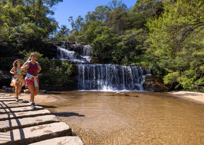
This return walk starts at the Wentworth Falls picnic area and takes you to one of the most popular waterfalls in the region: Wentworth Falls. There are a few vantage points to view the magnificence of Wentworth Falls but the best on this track is Fletcher’s lookout.
This moderate bushwalk is perfect if you plan on visiting other sights in the Blue Mountains. In that case, check out nearby Wentworth Falls village, one of the most beautiful towns in the area. Take a few more steps down (on the Charles Darwin Walk) and check out where Jamison Creek cascades into a shallow pool.
Region: Ku-ring-gai Chase National Park
Steeped in Aboriginal history, this loop features ancient rock engravings and art of the traditional owners of the land. Starting from the Resolute picnic area in Ku-ring-gai Chase National Park, the route takes you to West Head lookout, Resolute Beach, Red Hands Cave (where you will find historic rock Aboriginal engravings) and back.
West Head offers impressive views of Pittwater, Barrenjoey Lighthouse and beaches as far as Patonga and Umina. Lush picnic spots and native birds are aplenty, so pack your binoculars and food for lunch.

Resolute Beach, Ku-ring-gai Chase National Park
Region: Western Suburbs
Just south of Campbelltown, you’ll discover a family-friendly bushwalk that’s only a short drive from Sydney’s CBD in Dharawal National Park. The track offers plenty of bird-watching and wildlife-spotting opportunities. As you walk past tall scribbly gums and red bloodwoods look out for goannas, wallabies and the nectar-loving Holland honeyeater.
The walk extends to O’Hares Creek lookout where you can eat your packed lunch and delight in spectacular views of bushland. If you fancy a dip, continue on to the Jingga walking track where you’ll find a beautiful freshwater swimming hole.

Jingga walking track, Dharawal National Park - Credit: Nick Cubbin, DPIE
Region: Northern Beaches
Take a bus or car to the Northern Beaches of Sydney for an invigorating bushwalk through diverse ecosystems, past wildlife and over bridges. Relax and take a minute at the Cement Works Lookout for beautiful views across the lagoon. Fun fact: this route can also be done on a bike, so bring two wheels and cycle the path if you are short on time.
This trail caters for everyone with wheelchair access from the Berry, Jamieson, Middle Creek and Bilarong car parks, and toilets at several locations. Pack a picnic to have at one of the many barbecue and picnic areas, otherwise pull up a chair at a cafe found on the route.

Narrabeen Lagoon Trail, Narrabeen
Region: Blue Mountains
For a relaxing bushwalk, head to Rigby Hill in the Blue Mountains National Park. It’s a return walk from Pierces Pass with a gentle hill climb to spectacular views of Perrys Lookdown, and across the Grose Wilderness and Grose River.
You can get to the track from Bells Line of Road, between the Mount Wilson and Mount Banks turnoffs, down Pierces Pass Road. There’s a picnic area at the start of the trail, so once you’ve taken in the sights, head back for a lunch break or snack.
If you decide to tackle the Pierces Pass trail, which starts from the same spot, be prepared. It's a 16-kilometre return walk that can take up to eight hours, so it’s one for experienced bushwalkers only.

Blue Mountains National Park, Mount Wilson - Credit: David Noble/DCCEEW
Region: Sydney North
Capture amazing views of Sydney Harbour as you bushwalk from Taronga Zoo, past Chowder Bay and onto Balmoral Beach. You’ll take in famous landmarks, the Opera House and the Harbour Bridge while boats and ferries sail past. History lovers should stop off at Bradleys Head to check out military relics including a battery built in 1839.
There are cafes and restaurants at Chowder Bay to buy lunch (Ripples Chowder Bay is especially popular for its water views), or pack a picnic and roll out your rug at nearby Clifton Gardens. The beautiful Balmoral Beach also offers cafes and is the perfect end destination to relax and re-energise.
It’s a one-way track so you’ll need to organise transport at the end. Jump on a bus or ferry, or take the walk back to your car.

Bradleys Head to Balmoral Beach walk, Sydney North
Region: Sydney North
For a tranquil experience, go north of Sydney’s CBD and walk from the Spit Bridge, Mosman to Manly wharf. You can start the stretch at either end and from the CBD, catch a ferry to Manly wharf or a bus to Mosman.
Prepare to see a collection of locations that are postcard Sydney. You’ll trek through tree canopies and native bushland, and past secluded inlets and family-friendly rock pools. Look out for Aboriginal rock engravings by the local Cammeraygal people, and take a detour to the Grotto Point Lighthouse, an active beacon near Dobroyd Head.
There are plenty of hidden beaches for a refreshing dip. Grab a bite to eat and a refreshing drink at the many cafes, restaurants and bars that bookend the walk, or along the way at Clontarf Reserve.

The Spit Bridge to Manly Walk, Clontarf
Region: Western Suburbs
Head west of Sydney’s CBD to Parramatta and find a bushwalk that follows the edge of a decommissioned dam now called Lake Parramatta. Take the loop and explore unspoilt bushland featuring wildflowers, shrubs, trees and grasses of the Sydney Sandstone Gully Forest.
The bushland is also home to smooth-barked apple and blackbutt trees where sugar gliders and echidnas nestle. In summer you can enjoy a refreshing dip in the lake and other nearby facilities such as a playground, public toilets, picnic and barbecue area, a cafe and boat hire. For a shorter amble, try the She-oak Track (1.5 kilometres return) or the Banksia Track (2.4 kilometres return).
To get there, park your car at the 68-spot car park or take public transport via train and bus. You can enter via Lackey Street via Bourke Street North Parramatta. Avoid the walk in wet weather as it becomes impassable.

Parramatta River, Parramatta
Region: Royal National Park
The Bundeena to Wedding Cake Rock coastal walk is truly a slice of paradise. This walk makes up just one section of the 26-kilometre Coast Track that runs along the sandstone cliffs of the Royal National Park.
Starting at Beachcomber Avenue in Bundeena, the trail traverses over sand, rock and bush as it hugs the ocean coastline. The trail is full of stunning scenery, flowers and wildlife. Make sure to pack water, snacks and sun protection as the trail is quite isolated with little shade and no facilities.

Bundeena to Wedding Cake Rock walk, Royal National Park - Credit: DPE
Region: Blue Mountains
Starting at Wentworth Falls and ending at Katoomba, the Grand Cliff Top Walk is an ideal way to see many of the highlights in the Blue Mountains National Park: discover Aboriginal culture, spectacular lookouts (such as Empress Falls Lookout and Olympian Lookout), the Three Sisters, numerous waterfalls and quaint villages. Spanning two days, stay overnight in Leura and try the excellent restaurants, pubs and boutiques.

Grand Cliff Top Walk, Wentworth Falls - Credit: Remy Brand | DCCEEW
Sydney.com is the official tourism site for Destination NSW.
© Copyright 2026 Destination NSW. All rights reserved